
"Today we are opening up one of the world’s most reliable and comprehensive databases on developing economies. It includes more than 2,000 indicators from countries around the world, including hundreds that go back 50 years."
"Today we are opening up one of the world’s most reliable and comprehensive databases on developing economies. It includes more than 2,000 indicators from countries around the world, including hundreds that go back 50 years."


Flightradar24.com shows live aircraft traffic in the airspace above Europe. Click on "About" above to get more info about this page or here to know more about the map and how to contribute!.Also visit our forum to discuss the radar.

Play UK prime minister and set the policy on energy, transport and other sectors and measure the carbon emissions generated.
• The tool shows the UK as it is today
• Move the sliders and aim to reduce emissions by 80%
• You must supply enough electricity to meet demand. Make sure the scales are balanced
• Find out more about this tool and how we built it
• See how the Liberal Democrats, the Conservatives and Labour would cut emissions
Interactive: National carbon calculator - can you cut UK emissions? | Environment | guardian.co.uk
Of Dubai's absurd dreams, none has failed more spectacularly than The World - 300 man-made islands sculpted from sand;
only 'Geenland' has been built on. And as Adam Luck reports, the $14bn dream has left a trail of death, debt and deception
How Dubai's $14 billion dream to build The World is falling apart | Mail Online

About a year ago the United Nations announced UNdata, a way to disseminate data stretched out across 22 United Nations databases through one central application. While UNdata houses 66 million records, it's tough to get a sense of what's going on without a visual representation.
Progress is an effort to make this world data visible. More than anything though, it was a chance for me to mess around with some data.
Biodiversity is the variety of life on earth at all levels. Photographer: Paul A Souders/Corbis
What is biodiversity?
Biodiversity is the variety of life on earth at all levels: from genes to species to ecosystems. An apple variety is an example of biodiversity; so is Siberian coastal tundra. Most of the time, though, biodiversity is spoken about in terms of species.
The Great Barrier Reef is threatened by the worst environmental disaster in Australia's history after a ship ran aground. So why are giant coal carriers allowed to use this well-known shipping hazard as a shortcut?


Bristol is the UK's most bike-friendly big city, while London is one of the least hospitable to cyclists, according to a survey.The study by Cycling Plus magazine took the country's 20 biggest cities and towns by population – thus excluding traditional bike centres such as Cambridge and York – and ranked them using a series of factors including cycle commuter numbers, levels of bike theft, the number of traffic-free bike lanes, casualties, pollution and even rainfall.Bristol edged out Nottingham and Leicester, while London was rated 17th, above only Glasgow, Birmingham and bottom-placed Bradford.
The accolade for Bristol comes two years after it was named the country's first "cycling city" by the Department for Transport, giving it access to around £20m in extra funding for bike-related schemes. The city is also the birthplace of Sustrans, the green cycle route charity which began 30 years ago when volunteers converted an old rail line between Bristol and Bath into a dedicated bike route.
Bristol tops list of bike-friendly cities | Life and style | The Guardian
Early on Sunday morning (the 21st of March) eruption started at Fimmvorduhals, an area between Katla volcano and Eyjafjallajokull glacier and a popular hiking trail. Fear remains that the eruption at Fimmvorduhals might trigger a much larger eruption in Katla volcano. If that happens, these webcams will provide a direct view of the events.
The two new webcams showing Eyjafjallajokull glacier and provide a view of the eruption area were installed by Mila. The Hekla webcam (bottom of page) was installed in partnership between Iceland´s National Radio, Iceland´s Civil Protection Department and Siminn telephone. Volcanic activity is best viewed during dusk (6pm-8pm local time) as night falls and daylight reduces.
Webcam location map
- Webcam 1 of Eyjafjallajokull
- Webcam 2 of Eyjafjallajokull
- Webcam 3 of Eyjafjallajokull
(english version by Vodafone)
Reykjavik Iceland Volcano Webcams - Hekla and more... - My Reykjavik Info

Toads able to detect earthquake days beforehand, says study | Science | guardian.co.uk
South Downs National Park designation takes effect – 31 March 2010
The new South Downs National Park is designated at a minute past midnight on Wednesday 31 March. Covering an area over 1600 square kilometres, the South Downs National Park is the tenth National Park to be designated in England, offering an area of protected countryside that everyone can visit and enjoy. The famous South Downs Way, loved by walkers, cyclists and horse riders, stretches the entire 160 km length of the Park from Winchester in Hampshire to the white chalk cliffs of Beachy Head, near Eastbourne.

As a lover of our planet, Graverson Green, like us, is not a fan of dirty coal. Cue Coalfinger, a coal super villain and Green's ultimate enemy! Along with his dopey sidekick Dr. Anthracite, Coalfinger plans to cover the world in coal-fired power stations and destroy the climate. Can Green stop them with the help of his assistant Katrina Hurkane?

Britain's richest and poorest regions have drawn farther apart since 1995, with workers in London and the south-east seeing their income race ahead of the national average, while those in the rest of the country fell behind, official figures reveal.
The north-south pay gap: what do people earn where you live? | News | guardian.co.uk

Professor James Lovelock, the scientist who developed Gaia theory, has said it is too late to try and save the planet.The man who achieved global fame for his theory that the whole earth is a single organism now believes that we can only hope that the earth will take care of itself in the face of completely unpredictable climate change.
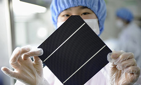
China renewable energy: An employee displays a solar panel at a workshop in a factory in Hangzhou, Zhejiang province. Photograph: LANG LANG/REUTERS
China has overtaken the US for the first time in a league table of investments in low-carbon energy among the G-20, according to a new report by not for profit group the Pew Charitable Trusts published this week.
How China overtook the US in renewable energy | News | guardian.co.uk
High-pressure fragrance sprays will be installed at Asuwei dump, one of several hundred overflowing landfill sites that are the focus of growing public concern 
In pictures: zooming in on Beijing's rubbish
Beijing to sweeten stench of rubbish crisis with giant deodorant guns | Environment | guardian.co.uk
The owner of a house on a Scarborough cliff edge has hosted a special dinner as a farewell gesture to the property. Teetering on the edge of Knipe Point in Scarborough, the property is at risk of falling off the cliff as it crumbles. Owner Kane Cunningham invited twelve guests to the bungalow's "last supper" to highlight the perils of climate change.

BBC News - Volcano erupts near Eyjafjallajoekull in south Iceland

The internet has created many new opportunities for people to get richer around the world.But are the benefits of access to the net filtering down to the very poorest in society? A shanty town in Brazil is a good place to find out. Babilonia is a favela, a slum district, of about 80,000 inhabitants, most of them very poor. It's located in Brazil's second city Rio de Janeiro, close to the world famous Copacabana beach.

A film illustrating the devastating impact that tar sands developments in Alberta, Canada are having on the environment and native First Nation communities

Britain's demand for imported goods is responsible for more greenhouse gas emissions abroad than any other European country, according to a new study published today.
The report shows that 253m tonnes of carbon dioxide are released overseas each year in the manufacture of products bound for UK shores, the equivalent of 4.3 tonnes per person. The average Briton's carbon footprint is 9.7 tonnes, not including emissions from goods.
UK import emissions are the highest in Europe, figures show | Environment | guardian.co.uk

In 
Over the decade from 2000 to the end of 2009, the yearly average was 78,000, according to the United Nations International Strategy for Disaster Reduction (ISDR). For the 1990s, the average was 43,000, and the 1980s was 75,000. Disaster experts say the rise in tragedy is at least partly due to increases in urban populations.
A Disastrous Year: 2010 Death Toll Already Abnormally High | LiveScience

The Chile tsunami was generated by a Mw 8.8 earthquake (35.846°S, 72.719°W ), at 06:34 UTC, 115 km (60 miles) NNE of Concepcion, Chile (according to the USGS). In approximately 3 hours, the tsunami was first recorded at DART® buoy 32412. Forecast results shown below were created with the NOAA forecast method using MOST model with the tsunami source inferred from DART® data. The tsunami waves first arrived at Valparaiso, Chile (approximately 330 km northeast from earthquake epicenter ), at 0708UTC, about 34 minutes after the earthquake.

NOAA Center for Tsunami Research - Tsunami Event - February 27, 2010 Chile

Deals can be good news when not made behind closed doors | Environment | The Observer

Know Your Flood Risk is a campaign with a mission to help raise awareness of the issue of flood and encourage practical guidance and support to help protect homeowners and property professionals against the risks.
Why join the campaign?
By signing up to the campaign you will join a community of organisations whose goal is to raise awareness of flood information and the potential risks. As a collective voice, Know Your Flood Risk and its members aim to raise the profile of flooding and ensure consumers are not only aware of the risks they face, but also how to mitigate them.
Growth of the INTERNET with interactive map from the BBC

The air is full of carbon dioxide and other pollutants;
The ocean is emptying;
We have observed record setting harvests over the last few years, and yet chronic hunger persists and has recently been increasing;
The planet is experiencing the 6th great extinction;
All of these are the result of human activity.

An Observer investigation reveals how rich countries faced by a global food shortage now farm an area double the size of the UK to guarantee supplies for their citizens
How food and water are driving a 21st-century African land grab | Environment | The Observer

France was today struggling to cope with its most violent storm for 10 years, as winds of more than 100mph swept through the country, killing at least 40 people and leaving 1m homes without power. Central and western France were worst hit with gales and torrential rain felling trees and causing flooding. At least seven people drowned in villages in the Vendée, while three elderly people and a child were found dead in Charente Maritime around La Rochelle. A man was killed by a falling tree branch in the south-western town of Luchon, where winds reached 90mph. As well as the known casualties, at least five other people were reported missing and dozens others injured. As the storm, known as Xynthia, progressed northwards through France over the weekend, five of the country's 95 departments were placed on red alert for only the second time in the emergency system's history. By this afternoon the alert had been downgraded.
Fatal storm sweeps through France | World news | guardian.co.uk
A news report from the event can be seen here:
http://news.bbc.co.uk/1/hi/world/europe/8541958.stm
The damage was particularly bad because of a storm surge which broke through inadequate defences:
http://news.bbc.co.uk/1/hi/world/europe/8544002.stm
There is more about storm surges here:
http://dlgb.wordpress.com/2007/11/29/the-november-2007-storm-surge/
and about the devastating 1953 storm surge here:
http://dlgb.wordpress.com/2007/11/29/the-1953-storm-surge-what-really-happened/
The storms are part of a series of strong winter storms which have affected western Europe:
http://news.bbc.co.uk/1/hi/world/europe/8540762.stm
Amongst the worst was the one which caused severe damage on the island of Madeira:
http://news.bbc.co.uk/1/hi/world/europe/8526288.stm

MetLink is the flagship education portal of the Royal Meteorological Society
We provide teachers, students, meteorologists and the general public with information about teaching weather and climate, teacher development, climate change and accreditation.
On this site you will find teaching materials including powerpoint presentations and lesson plans, information about becoming a meteorologist, how to obtain chartered status and many more things.
You will also find general information for teaching weather, curriculum links, information about school and junior membership and how to book a "Meteorology Ambassador" to come and talk to your class
What do you get when you mix fast heavy planes with small island airports? A hair-raising final approach! Let’s take a look at three scariest airports to fly into in the Caribbean.
Princess Juliana International Airport, St. Maarten (SXM)Passengers arriving into Princess Juliana often fly just a few metres over the head of sunbathers below on Maho Beach. The combination of screaming jet aircraft and beautiful tropical scenery in such close proximity make this airport a mecca for the world’s plane spotters. In fact, check out this video showing the arrival of a 747, shot by yours truly on a 2004 trip.

Arrival isn’t the only exciting part of this airport either; departing aircraft must make an immediate right hand turn to avoid flying directly into the 317 m St. Peter Hill. At the same time, the departing planes blow a massive amount of jet blast back onto Maho Beach – so strong is the blast that it can cause you and your belongings to be blown right into the water if you’re not careful.
Top 3 Scariest Airports in the Caribbean - Google Sightseeing

An iceberg the size of Luxembourg that contains enough fresh water to supply a third of the world's population for a year has broken off in the Antarctic continent, with possible implications for global ocean circulation, scientists said today.
The iceberg, measuring about 50 miles by 25, broke away from the Mertz glacier around 2,000 miles south of Australia after being rammed by another giant iceberg known as B-9B three weeks ago, satellite images reveal. The two icebergs, which both weigh more than 700m tons, are now drifting close together about 100 miles north of Antarctica.
Giant Antarctic iceberg could affect global ocean circulation | Environment | guardian.co.uk

Which products does does the UK export, and where does it export them to?
UK export and import in 2009: top products and trading partners | News | guardian.co.uk
Eve


The Greenwich Millennium Village (GMV) is an innovative mixed-tenure modern housing estate on an urban village model located on the Greenwich Peninsula in Greenwich in south-east London, and part of the Millennium Communities Programme under English Partnerships (now renamed Homes and Communities Agency). The village is designed by architects Ralph Erskine and partners with EPR Architects Ltd as executive architect as part of the regeneration of the whole brownfield site of Greenwich Peninsula former town gas works. GMV is south of the former Millennium Dome, now renamed the O2.
The village on the southern banks of the Thames, about one mile upstream from the Thames Barrier and adjacent to its own purpose-built Ecology Park, cycle paths and recreational areas. The village currently has the Millennium Primary School and a medical GP surgery. Next to the complex, at Peartree Wharf, is the Greenwich Yacht Club, a modern building provided by English Partnerships.
The Village is being developed by a consortium of Countryside Properties and Taylor Wimpey. The housing is of modern, environmentally-friendly design, and the development aims to cut primary energy use by 80% using low-energy building techniques and renewable energy technologies. GMV is planned by the developers to continue to expand until about 2015, with its own integrated village shopping and community centres. As of 2008, 1,095 homes and a village square with shops have been completed.
http://www.englishpartnerships.co.uk/gmv.htm

Greenwich Millennium Village - Wikipedia, the free encyclopedia


