
The continent of Antarctica is warming up in step with the rest of the world, according to a new analysis.
Scientists say data from satellites and weather stations indicate a warming of about 0.6C over the last 50 years.
The continent of Antarctica is warming up in step with the rest of the world, according to a new analysis.
Scientists say data from satellites and weather stations indicate a warming of about 0.6C over the last 50 years.


Race Against Global Poverty is an interactive educational quiz game from DFID. Aimed at young people aged 11 to 16, the online game makes learning about the developing world fun and stimulating.

Featuring attractive animation and animal characters, it increase players' understanding of development through questions about world poverty and DFID's work to tackle it. The game is one of a range of activities that DFID is providing to young people to raise their awareness of development issues and get them involved in the fight against poverty.  Play the game online here.


By the year 2000, half the world's poor were in Africa.
It is the only continent to have become poorer in the past 25 years.
This is because of several reasons:

The Places project is our way of saying thank you to all our members who’ve taken the time to put their gorgeous photos and video on the map. Browse the whole globe, from your hometown to your favorite place, or places you’ve never even heard of...

Three months after the end of the games, new figures show the "Olympic Effect" has been short-lived and hotels are empty, industrial output has fallen and the streets are quiet.
Much of the pain is due to the worldwide financial crisis – and in some cases due to brave decisions by the government to keep polluting industries shut to spare the environment.
But even the biggest single symbol of the modern rise of China, the "Bird's Nest" National Stadium, stands forlorn, largely unused except for a shrinking number of tourists.
Repeat photography is a technique in which a historical photograph and a modern photograph, both having the same field of view, are compared and contrasted to quantitatively and qualitatively determine their similarities and differences. The following sections depict how this technique was used at a number of locations in Alaska, including Glacier Bay National Park and Preserve, Kenai Fjords National Park, and the northwestern Prince William Sound area of the Chugach National Forest, to document and understand changes to glaciers and landscapes as a result of changing climate. Through analysis and interpretation of these photographic pairs, information is extracted to document Alaskan landscape evolution and glacier dynamics for the last century-and-a-quarter on local and regional scales and the response of the Alaskan landscape to retreating glacier ice.
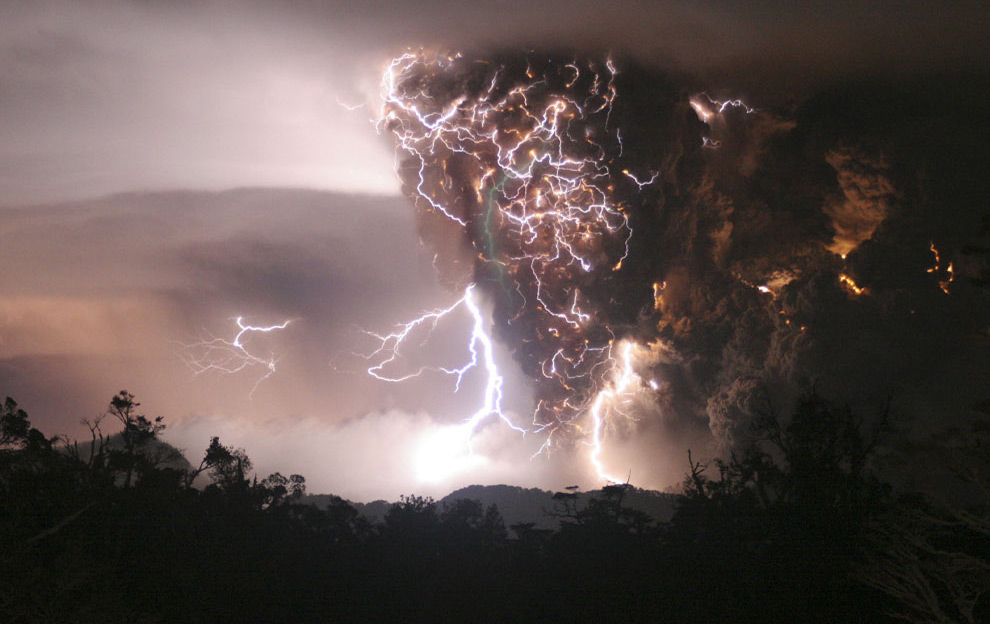
2008 has been an eventful year to say the least - it is difficult to sum up the thousands of stories in just a handful of photographs. That said, I will try to do what I've done with other photo narratives here, and tell a story of 2008 in photographs. It's not the story of 2008, it's certainly not all stories, but as a collection it does show a good portion of what life has been like over the past 12 months.


This unit of work teaches resilience in the context of water and flooding. It delivers an understanding of awareness, preparedness and knowledge of what actions should be taken in the event of flooding; and of how changing physical and human processes bring about flooding in the first place. This unit nurtures vital skills for what might be termed "environmental citizenship", giving life-long advice about the protection of homes - and the need to always keep an open and inquiring mind that can identify risk.
The first half of the unit deals with flood risk in the UK - a key aspect of life on these islands. Basic Environmental Agency rules for adults (be aware, be prepared, know how to act) are looked at. The causes of flooding are then examined, including human accidents (plumbing). As part of the work, a local risk assessment should be conducted for home or school, using the engaging technique of flood-depth analysis - working out what losses different levels of water could bring to a room or building!
The second half of the unit returns to the theme of resilience and explores in greater depth the steps that students' parents or guardians can take in protecting their homes from possible flood or storm damage. Flood kits and flood-proofing techniques are examined before moving on to think about flood warnings. A close look is taken here at how new digital technologies can help get warnings to people quickly. There are plenty of opportunities for role playing also, through thinking about vulnerable people, such as the hard-of-hearing, for whom text message warnings have been a real blessing. Greater cultural understanding is fostered.
The unit closes with a look at the interdependence that exists between different groups of people and businesses living on flood plains. Using the metaphor of "river team players", students will think about how local groups can work together to try and build community resilience to flooding (becoming sensitive to the risks associated with some land-use changes). Attention is thus paid to the citizenship dimensions of flood management.
The UK has less available water per person than most other European countries. London is drier than Istanbul, and the South East of England has less water available per person than the Sudan and Syria. Water is scarce in parts of Scotland, Wales and Northern Ireland as well as in England - large scale drought is already occurring in the UK, with the lowest rainfall, groundwater and reservoir levels for decades. Each person in the UK currently uses about 150 litres of water every day. This has been rising by 1% a year since 1930. This consumption level is not sustainable in the long-term.
f we do not take action now, climate change, population shifts and behaviour mean the UK will face increased water stress in the future.


It is a statement of the obvious that water is the most critical factor related to drought. Whilst lack of water is the primary cause of drought, there are a large number of factors which exacerbate and intensify the effects of lack of water. If these factors, many of which have little to do with water per se, are adequately managed, the consequences of the lack of water can be greatly reduced. For this reason drought management policy must take into account a wide variety of factors.
"In popular usage, "scarcity" is a situation where there is insufficient water to

Water is essential for human survival and well-being and important to many sectors of the economy. However, resources are irregularly distributed in space and time, and they are under pressure due to human activity.

Water metering in areas affected by serious water shortages is being proposed by the government and the Environment Agency.
A preliminary map of "water stressed" parts of England has been produced, with the whole of the South East being classified as "serious".

The alarming extent of water scarcity across the world is detailed in a map compiled by a leading environmental think tank.
It shows two key types of scarcity; water is said to be either physically scarce or economically scarce.

Natural disasters killed over 220,000 people in 2008, making it one of the most devastating years on record and underlining the need for a global climate deal, the world's number two reinsurer said Monday. Skip related content
http://uk.news.yahoo.com/18/20081229/tsc-natural-disasters-killed-o...
http://www.munichre.com/en/press/press_releases/2008/2008_12_29_pre...
http://www.munichre.com/en/ts/geo_risks/default.aspx
http://www.munichre.com/en/ts/geo_risks/natcatservice/annual_statis...
http://www.munichre.com/en/ts/geo_risks/natcatservice/long-term_sta...
http://www.munichre.com/en/ts/geo_risks/natural_catastrophes_and_ri...


